

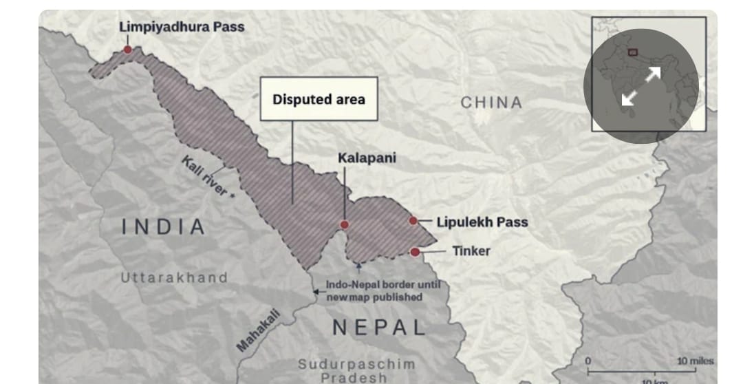
The Lipulekh Pass dispute has once again become a diplomatic flashpoint between India and Nepal. The pass lies in the Pithoragarh district of Uttarakhand. In May 2026, India and China finalised plans to resume the Kailash Mansarovar Yatra via this route. Soon after, Nepal formally raised a diplomatic objection. Kathmandu claims that the route cuts through its sovereign territory. Thus, an old, unresolved boundary dispute is back in the spotlight.

Syllabus Relevance
- UKPSC Mains (GS Paper I): Geography and history of Uttarakhand; borders and strategic importance of Uttarakhand.
- UKPSC Mains (GS Paper II): International relations (India–Nepal bilateral relations).
- UKPSC Prelims: Important passes, rivers, treaties and current affairs of national and international importance.
Lipulekh Pass Dispute: Location and Strategic Importance
- The tri-junction: Lipulekh is a strategic Himalayan pass. It sits at the tri-junction of India (Uttarakhand), Nepal and China (Tibet).
- Kailash Mansarovar route: Moreover, it offers the shortest and most accessible land route from India to Mount Kailash and Mansarovar Lake in Tibet.
- Strategic value for India: For New Delhi, control over Lipulekh, Kalapani and Limpiyadhura is critical. Specifically, it helps India monitor Chinese movements across the Line of Actual Control (LAC).
Root Cause of the Lipulekh Pass Dispute: Treaty of Sugauli (1816)
The conflict stems from old maps and differing readings of the Treaty of Sugauli. The British East India Company and the Kingdom of Nepal signed it in 1816, after the Anglo-Nepalese War.
- The border demarcation: The treaty made the Kali River (also called the Mahakali or Sharda) Nepal’s western boundary with India.
- The core ambiguity: However, the treaty did not clearly define the exact source of the Kali River. Nor did it attach a map. As a result, two competing claims emerged:
- Nepal’s stance: Kathmandu argues that the Kali River rises at Limpiyadhura, further northwest. Under this view, Limpiyadhura, Kalapani and Lipulekh all fall within Nepal. Nepal cites certain 19th-century British maps in support.
- India’s stance: In contrast, New Delhi holds that the river rises from springs near Lipukhola, close to the Lipulekh Pass. India points to historical administrative records, revenue collection and continuous control since the mid-20th century.
Why the Kailash Mansarovar Yatra Triggered the Dispute
Nepal’s objection is territorial. Still, the planned resumption of the yatra acts as a catalyst for several reasons:
- Legitimising the status quo: When India and China jointly organise a pilgrimage or trade route through Lipulekh, it normalises Indian control. Consequently, Nepal’s claims weaken on international platforms.
- No trilateral consultation: Kathmandu was unhappy that India and China did not consult it about the transit route. After all, it claims the land.
- Domestic political constraints: In 2020, Nepal amended its constitution to adopt a new political map. This map includes Limpiyadhura, Kalapani and Lipulekh. Therefore, no government in Kathmandu can stay silent without facing severe domestic backlash.
India’s Position and Historical Continuity
India has firmly rejected Nepal’s unilateral claims. It calls them an “artificial enlargement of territorial claims.” India’s defence rests on two main pillars:
- Historical continuity: India has used Lipulekh as an official trade and pilgrimage corridor since the 1954 Sino-Indian Agreement. Indeed, Indian pilgrims have used this route for decades without interference.
- Bilateral dialogue: Moreover, India holds that boundary disputes need mature bilateral dialogue through institutional mechanisms. In its view, unilateral map changes cannot settle them.
Lipulekh Pass Dispute: Implications for Uttarakhand
For UKPSC aspirants, note that this dispute directly affects Uttarakhand:
- Local economy: The Kailash Mansarovar Yatra supports religious tourism and livelihoods in Kumaon, especially Pithoragarh district. Hence, geopolitical tension can disrupt local incomes.
- Infrastructure development: India has built strategic border roads here, such as the 80-km road from Dharchula to the Lipulekh Pass. Such projects remain vital for national security. They also aid development in Dharchula and nearby border blocks.
Way Forward
- Diplomatic engagement: India and Nepal share deep historical, cultural and open-border ties, often called “Roti-Beti Ka Rishta.” Therefore, the dispute needs dialogue at the Joint Boundary Committee level to assess historical maps technically.
- Confidence building: Finally, quiet diplomacy works better than public rhetoric. It can prevent external actors from exploiting bilateral friction.
Expected Questions for UKPSC Practice
Prelims-oriented questions:
- The Treaty of Sugauli (1816) was signed between the British East India Company and which of the following?
- (A) Kingdom of Tibet
- (B) Kingdom of Nepal
- (C) Chogyal of Sikkim
- (D) Nawabs of Awadh
- Answer: B
- The Lipulekh Pass, recently in the news, is located in which district of Uttarakhand?
- (A) Chamoli
- (B) Uttarkashi
- (C) Pithoragarh
- (D) Bageshwar
- Answer: C
Mains-oriented practice question:
- “The geopolitical friction at the Lipulekh Pass is a product of historical cartographic ambiguity.” Analyze this statement in the context of India-Nepal border relations and its impact on the strategic interests of Uttarakhand. (150-250 Words, 10/15 Marks)
For India’s official position, see the Ministry of External Affairs. Also, read our note on the road network of Uttarakhand, including BRO border roads.
Preparing for the UKPSC Upper PCS 2026 prelims? Join our UKPSC 2026 Prelims Test Series for regular practice.