Topic: Lipulekh Pass Dispute & Kailash Mansarovar Yatra: The Geopolitics of a Pilgrimage Route
Syllabus Relevance: * UKPSC Mains (GS Paper I): Geography and History of Uttarakhand, Borders and Strategic Importance of Uttarakhand.
- UKPSC Mains (GS Paper II): International Relations (India-Nepal Bilateral Relations).
- UKPSC Prelims: Important Passes, Rivers, Treaties, and Current Affairs of national and international importance.
Introduction
The Lipulekh Pass, situated in the Pithoragarh district of Uttarakhand, has emerged as a significant diplomatic flashpoint between India and Nepal. In May 2026, as India and China finalized plans to facilitate the resumption of the Kailash Mansarovar Yatra via the Lipulekh Pass route, Nepal formally registered a diplomatic objection. Kathmandu claims that the pilgrimage route cuts through its sovereign territory, bringing an old, unresolved cartographic boundary dispute back into the geopolitical spotlight.
Geographic Location and Strategic Importance
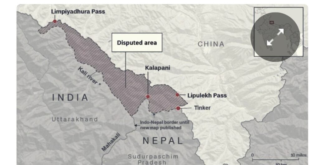
- The Tri-Junction: Lipulekh Pass is a strategic Himalayan pass located at the tri-junction of India (Uttarakhand), Nepal, and China (Tibet).
- Kailash Mansarovar Route: The pass provides the shortest and most accessible land route from India to Mount Kailash and Mansarovar Lake in Tibet.
- Strategic Value for India: For New Delhi, maintaining administrative and military control over Lipulekh, Kalapani, and Limpiyadhura is critical for monitoring Chinese movements across the Line of Actual Control (LAC).
Root Cause: The Treaty of Sugauli (1816)
The geopolitical conflict is deeply rooted in historical cartography and differing interpretations of the Treaty of Sugauli, signed in 1816 between the British East India Company and the Kingdom of Nepal following the Anglo-Nepalese War.
- The Border Demarcation: The treaty established the Kali River (also known as the Mahakali or Sharda River) as Nepal’s western boundary with India.
- The Core Ambiguity: The treaty did not clearly define or attach a map specifying the exact source/origin of the Kali River. This single omission created two competing claims:
- Nepal’s Stance: Kathmandu argues that the Kali River originates at Limpiyadhura (further northwest). Under this interpretation, the entire region—including Limpiyadhura, Kalapani, and Lipulekh—falls within Nepal’s borders. Nepal backs this with certain 19th-century British maps.
- India’s Stance: New Delhi maintains that the river originates from a collection of springs near Lipukhola (close to the Lipulekh Pass). India asserts that historical administrative records, revenue collection, and continuous physical control since the mid-20th century validate its sovereignty over the area.
Why the Kailash Mansarovar Yatra triggered the Dispute
While Nepal’s objection is territorial, the planned resumption of the Kailash Mansarovar Yatra via Lipulekh acts as a catalyst for several reasons:
- Legitimization of the Status Quo: When India and China bilaterally coordinate a structured pilgrimage or trade route through Lipulekh, it normalizes Indian administrative control over the area. For Nepal, this weakens its claims on international platforms.
- Lack of Trilateral Consultation: Kathmandu expressed discontent because it was not consulted or included in the bilateral arrangement between India and China regarding the transit route, despite claiming the land.
- Domestic Political Constraints: In 2020, Nepal amended its constitution to adopt a new political map that explicitly includes Limpiyadhura, Kalapani, and Lipulekh. Due to this high-profile constitutional status, no political dispensation in Kathmandu can remain silent on the issue without facing severe domestic backlash.
India’s Position and Historical Continuity
India has firmly rejected Nepal’s unilateral claims, describing them as an “artificial enlargement of territorial claims.” India’s defense rests on two primary pillars:
- Historical Continuity: The Lipulekh Pass has been actively used as an official trade and pilgrimage corridor since the 1954 Sino-Indian Agreement. Indian pilgrims have used this precise route for decades without historical interference.
- Bilateral Dialogue Mechanism: India maintains that outstanding boundary disputes must be resolved through mature, bilateral diplomatic dialogue based on institutional mechanisms, rather than unilateral cartographic assertions.
Implications for Uttarakhand
For students preparing for the UKPSC, this dispute directly impacts the state of Uttarakhand:
- Local Economy: The Kailash Mansarovar Yatra is a major source of religious tourism and livelihood for the local communities in Kumaon, particularly the Pithoragarh district. Geopolitical tensions can disrupt local economies.
- Infrastructure Development: India’s construction of strategic border infrastructure in the region (such as the 80-km road linking Dharchula to Lipulekh Pass) remains vital for both national security and socioeconomic development in Dharchula and surrounding border blocks.
Way Forward
- Diplomatic Engagement: India and Nepal share deeply institutionalized, time-tested historical, cultural, and open-border ties (“Roti-Beti Ka Rishta”). The dispute requires a Joint Boundary Committee level dialogue to technically assess historical maps.
- Confidence Building: Quiet diplomacy, rather than public rhetoric, is essential to prevent bilateral ties from being weaponized by external actors in the region.
Expected Questions for UKPSC Practice
Prelims-oriented Questions:
- The Treaty of Sugauli (1816) was signed between the British East India Company and which of the following?
- (A) Kingdom of Tibet
- (B) Kingdom of Nepal
- (C) Chogyal of Sikkim
- (D) Nawabs of Awadh
- Answer: B
- The Lipulekh Pass, recently in the news, is located in which district of Uttarakhand?
- (A) Chamoli
- (B) Uttarkashi
- (C) Pithoragarh
- (D) Bageshwar
- Answer: C
Mains-oriented Practice Question:
- “The geopolitical friction at the Lipulekh Pass is a product of historical cartographic ambiguity.” Analyze this statement in the context of India-Nepal border relations and its impact on the strategic interests of Uttarakhand. (150-250 Words, 10/15 Marks)