Comprehensive Overview of Uttarakhand Disaster Resilient Preparation Initiatives
In recent high-level meetings chaired by Uttarakhand’s Chief Secretary regarding the state’s comprehensive approach to natural disaster mitigation, the following details outline key areas were discussed:
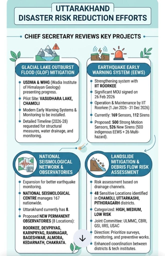
1. Glacial Lake Outburst Flood (GLOF) Mitigation
Recognizing the increasing threat from expanding glacial lakes in the Himalayas, the state is implementing specific measures with a scientific approach:
- Pilot Project and Key Agencies: Vasudhara Lake in the Chamoli district has been selected as the pilot site for developing GLOF mitigation strategies. The Uttarakhand State Disaster Management Authority (USDMA) and the Wadia Institute of Himalayan Geology (WIHG) are the lead agencies for this initiative.
- Technical and Structural Measures: The project at Vasudhara Lake will involve:
- The installation of state-of-the-art Early Warning Systems (EWS).
- Comprehensive monitoring mechanisms.
- Structural solutions, including controlled water discharge to manage and reduce the lake’s water level, mitigating the risk of a catastrophic outburst.
- Real-time monitoring and the development of a Decision Support System (DSS).
- Future Planning: WIHG has been directed to submit a detailed timeline for proposed activities for the periods 2026-27 and 2027-28, ensuring clear project execution milestones.
2. Earthquake Early Warning System (EEWS) & Network Strengthening
Uttarakhand is situated in Seismic Zones 4 and 5 (highly vulnerable), making robust earthquake warning and monitoring systems critical.
- Collaboration and MOU: The state is actively working with IIT Roorkee to strengthen the EEWS. A significant Memorandum of Understanding (MOU) was signed on February 26, 2026. Under this agreement, IIT Roorkee is responsible for the transmission of alerts, operation, and maintenance of the EEWS system from January 1, 2026, to December 31, 2026.
- Network Expansion:
- Current Infrastructure: 169 sensors and 112 sirens are presently active in the state.
- Upgrades: The National Earthquake Risk Reduction Program is deploying 500 Strong Motion Sensors across seismically sensitive areas.
- Early Warning Dissemination: 526 additional sirens are proposed (500 indigenous EEWS sirens and 26 multi-hazard early warning sirens) to improve alert dissemination.
- Seismological Observatories: The National Center for Seismology operates 167 observatories nationwide, with 8 currently located in Uttarakhand. Plans are underway to establish 8 new permanent observatories to strengthen monitoring in Roorkee, Devprayag, Karnprayag, Ramnagar, Bageshwar, Almora, Kedarnath, and Chakrata.
3. Landslide and Debris Flow Mitigation
To address the frequent occurrence of landslides and debris flows, especially during the monsoon season, a proactive risk assessment strategy has been adopted.
- District and Location Identification: 48 sensitive locations across Chamoli, Uttarkashi, and Pithoragarh districts have been identified.
- Risk-Based Classification: These locations are primarily situated around drainage channels (Debris Flow paths). They have been classified into High, Medium, and Low risk categories to ensure prioritized action.
- Expert Committee: A joint committee comprising technical expertise from various institutions has been formed to spearhead these efforts. Members include:
- Uttarakhand Landslide Mitigation and Management Center (ULMMC)
- Central Building Research Institute (CBRI)
- Geological Survey of India (GSI)
- Indian Institute of Remote Sensing (IIRS)
- Uttarakhand Space Application Centre (USAC)
- Directives for Action: Priorities have been set for immediate surveys, constant monitoring, and necessary preventive measures at the identified high-risk sites.
Focus and Directives
The review meetings, led by Chief Secretary Shri Anand Bardhan, emphasize:
- Prioritization: Urgent action at identified high-risk GLOF and landslide locations.
- Technological Integration: Utilizing advanced tech like early warning systems, real-time monitoring, and decision support systems across all programs.
- Time-Bound Progress: Agencies like WIHG are expected to submit clear, time-bound execution plans.
- Institutional Coordination: Stronger collaboration between district administrations and specialized technical and scientific institutions is paramount for success.
- Proactive Approach: Transitioning from reactive response to preventive mitigation and scientific risk management.
For Mains Exam (GS Paper – Disaster Management):
- Question: “Discuss the modern technologies being adopted for disaster mitigation in Uttarakhand.”
- Key Answer Points: Expansion of EEWS, Vasudhara Lake pilot project, Multi-hazard early warning sirens, and inter-institutional coordination (MOU with IIT Roorkee).
Facts:
- Fact: Where is Vasudhara Lake located? (Chamoli).
- Fact: When was the MOU for EEWS signed with IIT Roorkee? (February 26, 2026).
- Fact: In which 8 locations are the new observatories proposed? (Remember the names).
The Uttarakhand government is moving toward a ‘Preventive’ disaster management model rather than a ‘Reactive’ one. The coming together of academic bodies like IIT Roorkee and the Wadia Institute is a precise example of scientific policy-making